Title 1 | home
Title 1
The Sea Around Us
As I start this history in 2010 the matter of rising sea levels and how it relates to the low lying land that once formed the Wantsum Channel, which made Thanet an island, is a matter of considerable concern.
Other parts of Thanet particularly those on the foreshore are likely to be effected, in Ramsgate this mostly means the sands and harbour area.
Rising sea levels is no new thing, apart from the rises in prehistoric times caused by massive geological movements and the ending of ice ages, there has been a steady rise over the last hundred years of about eight inches or twenty centimetres.
It is still difficult to tell how much of this rise is man made and how much of it is the a natural occurrence as the sea has been mostly rising to a greater or lesser degree since the end of the last ice age.
The amount that sea has risen has been due to two factors. One is the melting of ice in the extreme north and south of the planet, this has the effect of putting more water into the sea, making the level rise. The other is the rise in the temperature of the sea, the warmer this mass of water becomes the more it expands, (like the liquid in a thermometer) this also makes the sea level rise.
At the moment these two factors are both causing about the same amount of rise in sea levels.
Sea level rises for the next hundred years are predicted at being between about two feet six inches or 0.8 metres and six feet six inches or two metres.
A big difficulty when determining what these figures mean in real terms, flooding, damage to low lying property and even death and injury, is that the sea is involved making the matter unpredictable.
Every so often in this part of the world we get a tidal surge storm, one of these storms occurred in 1953 and another in 1897.
There are various factors that determine how high the sea will go at high tide. The main regular and predictable one being the combined gravitational pull of the moon and the sun, this has most effect in the spring when they are closer to the earth. The other main but unpredictable one is caused by the barometric pressure over the sea in this area. An area of low pressure over the sea in this area causes it to rise and an area of high pressure over the sea causes it to fall.
The worst problems occur when a spring tide and an area of low pressure combine with a serious storm.
It is very unusual for all three to happen at once, in 1953 a normal high tide (not a spring tide) combined with low pressure over the sea and a storm.
During the 1953 storm the sea encroached on both ends of the low-lying land that once formed the Wantsum Channel. The most serous problem being on the northern coast where the sea defences between Reculver and Birchington were breached.
The result of this breach was that several square miles of farmland were washed away taking with it several miles of the railway line.
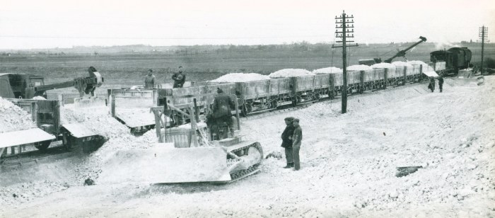
This picture shows the reinstatement work.
In Ramsgate the damage was mostly in the main sands area, information is fairly scanty as most of the news coverage related to the major devastation on the unsheltered north coast.
Damage was limited by the very large beach caused by the sand being held in place by the wartime sea defences, most of this sand was later removed for infill when Port Ramsgate was built.
The shallower the sea, the more the waves are reduced in size and the less damage the storm does.
The most notable incident I can find in Ramsgate was that the sea washed a twelve-ton crane, which had been working on the beach, over the sea defences and into the amusement park behind the main sands.
For the most part the low-lying developed areas of Ramsgate, that are adjacent to the sea, are protected from storm damage by Ramsgate Harbour and even with some rise in sea level this will probably be sufficient.
At the moment the exceptions to this are The Royal Victoria Pavilion, a building that has been flooded by the sea occasionally and the houses under the arches that form Granville Marina.
The Early Confused Period
To get to grips with the history of Ramsgate it helps to have some understanding of how The Isle of Thanet was formed, other history books and old maps are of some help with this but there is a lot of guesswork involved.
The history of the Wantsum channel that once divided The Isle of Thanet from the mainland is the subject of scholarly debate, even now there are uncertainties as to how and when it was formed and to when it silted up or was filled in.
To understand how The Isle of Thanet became an island you have to go back about 10,000 years ago around the end of the last ice age.
At this time Britain was still connected to the continent of Europe and Thanet was part of the whole landmass, during the great melt down the sea rose by about 1,000 feet.
It would be nice to consider this a gradual event, with people and animals getting out of the way, such historical documentation that exists relating to the sea regaining landmasses in this part of the world in more modern times, suggests that every 50 years or so there would have been a huge storm combined with a tidal surge, taking a large area of land and drowning a great many people and animals.
Putting together the conjectures of such scholars as I have read, it seems likely that somewhere around 6,000 years ago Thanet became an island.
The shape of that island would have been due to a mixture of two things, the height of the existing land (hills and valleys) and the rising sea level. Soon after this the action of costal erosion would have had a significant effect on this shape and for the most part the island would have been surrounded by cliffs.
Scholarly conjecture puts the size of The Isle of Thanet at this time at about three times today's size, with most of the extra landmass being to the north and east. I will refrain from attempting to draw a map, I have been looking at some others have drawn by historians over the years and will use some of those instead
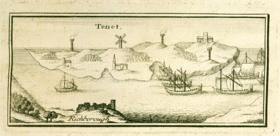
You can try a guess the date of the map above it comes from Lewis published in 1736 and obviously represents Thanet at a much earlier time.
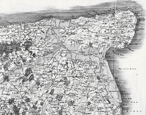
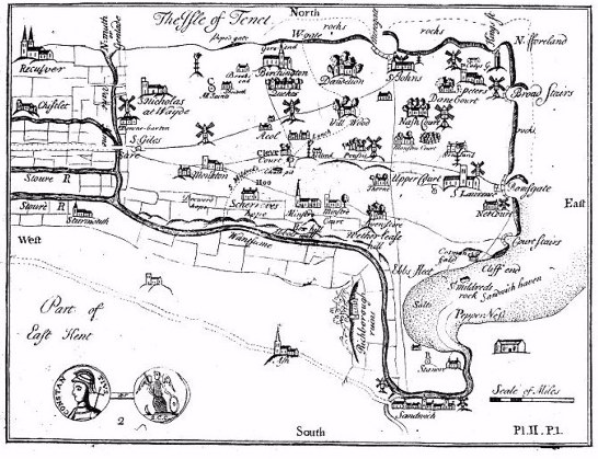
The 1830 Map above has all of the low lying areas shaded and this area is the nearest I can get to the shape of the Wantsum, you may as well make your own guess.
Mapmaking gets more misshapen the further you go back in time, but then so does our knowledge of the coastline,
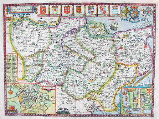
Above is John Speed's map of Kent in 1611 and as you can see there is no question of Thanet being cut off by a wide sea channel. You will also notice at this time the main towns in the area are Canterbury, Sandwich, Dover and Margate.
John Lewis who wrote the main history of Thanet in the early 1700s said that although he couldn't remember the Wantsum being navigable all the way through to the sea, he had spoken to an old person who could remember quite large vessels being able to get through.
This seems to roughly concur with the look of the 1611 map and I think it fairly safe to assume that it stopped being a navigable route between the Thames and the English Channel about this time.
You have to appreciate that as you go back in time vessels going between the two places get progressively smaller and less seaworthy and would be more likely to want to avoid going round the North Foreland if possible.
Indeed as late as the early 1800s when the first paddle steamers came to Thanet they avoided this feat of navigation and stopped at Margate.
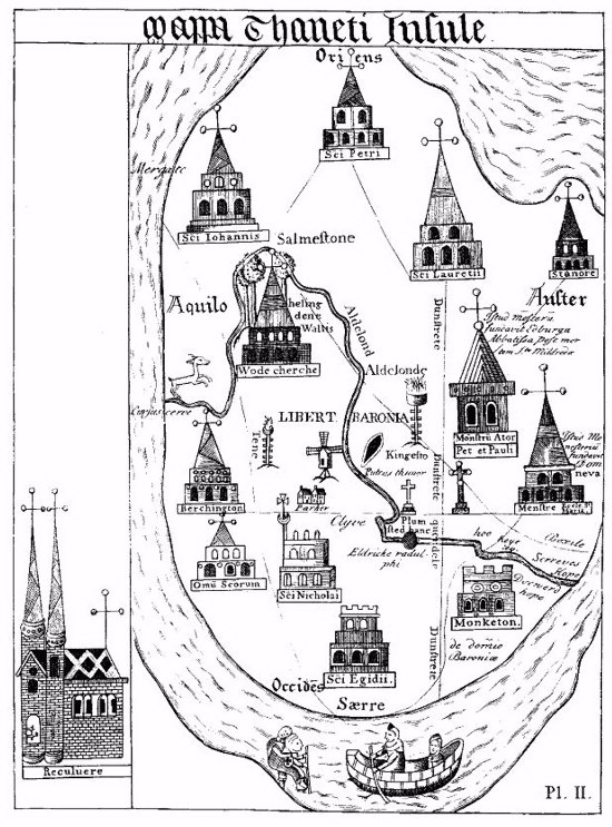
This map by Thomas of Elmham comes from the early 1400s and should be viewed this way round, to get north roughly at the top.
Another map from Lewis's history which I think is supposed to represent Thanet in the mid 1600s Lewis first published in 1723 and in the following edition of his book in 1736 he also published a map of Ramsgate showing it much more developed than the map above shows.
It is as well to remember that the first triangulation survey of England was in 1787, this was made for military purposes and I would imagine that it took some time for this to filter through into commercial maps.