The Cry From The Sea and the Answer From the Shore | Click here to buy the book or veiw our other local books
The Cry From The Sea and the Answer From the Shore | The Cry From The Sea and the Answer From the Shore 2 | The Cry From The Sea and the Answer From the Shore 3 | The Cry From The Sea and the Answer From the Shore 4 | The Cry From The Sea and the Answer From the Shore 5 | Margate Lifeboat | Ramsgate Lifeboat
The Cry From The Sea and the Answer From the Shore
Publishers notes
Rev. T Stanley Treanor wrote three books about the Goodwin Sands the first being Heroes of the Goodwin sands which is mainly about the work of the Deal, Walmer and Ramsgate Lifeboats, it is already in print published by another publisher. The next being The Log of a Sky Pilot. Seamen call clergymen sky pilots. That book is mainly about his work as the Missions to Seamen Chaplain for the Downs and is published by us in this format. This is his third and final book on the subjects covering as it does his work and that of the lifeboatmen. At this time Treanor's boat the lifeboats and all of the other small open boats were either powered by the wind or by the crew of the boat rowing it.
Treanor and his fellow crew members launched their open boat by sliding it down Deal beach on greased planks often jumping in at the last moment and getting the sail up before they were tossed back onto the beach by the waves. It is recorded that in one year he spent 250 days at sea, visited 400 homes and 890 ships. His work as a priest involved visiting the ships that were waiting off our coast for the weather to improve enough for them to continue on their voyages. For those of us interested in the lives of the people who provided goods and services to the shipping off our coast his books are invaluable as he was the only one of these seafarers to write of his life. In Deal where he lived, and the lives of the seamen there and in the other costal towns in this area, many of the local people had shares in a boat and made their living from the sea by a mixture of fishing, foying (taking out goods and offering services to the shipping) hoveling (salvaging wrecked vessels or their cargoes) carrying goods from abroad or other parts of this country, and smuggling.
Victorian clergymen played a very important role in their society, before social services the ordinary population, when they found themselves destitute were reliant on charity administered by the church. In many cases the clergy were the only well educated people that ordinary people had access to. The lot of ordinary seafarers was often fairly bad and the work of The Missions to Seamen important to them. In these days of a far more secular society when sailors are well paid and mostly have good working conditions it is hard for us to fully appreciate the work of men like Treanor. Within the seafaring community Treanor was also respected as a fine seaman, spending as much time at sea in a small open boat as he did, which is often is best described as long periods of boredom punctuated with short periods of abject terror. His understanding of the needs of other sailors was considerable.
Some of you may not have any experience of navigating a small boat off our coast, using the same equipment that was used in Victorian times. Some knowledge of how this is done helps to understand these books about the Goodwin Sands.
The equipment used is a chart which is a map of the sea, it shows how deep the water is where the buoys are and what they look like, the direction and speed of the tidal flow at different times in the tidal cycle, on the coast it shows landmarks, for night time navigation it tells you the colour and flashing sequence of the various navigational lights, for navigation in fog it tells you sequence of blasts of the foghorns and compass roses printed on it in several places.
A hand held compass with a sighting arrangement on it that allows you to take the bearing (direction around the compass) of anything you can see, normally the compass slots into some sort of holder in the boat in a way that it shows the direction the boat is pointing in.
A pair of parallel rulers, these are connected by two pivoted pieces of metal so that as you move them apart or together they remain parallel to each other. The older and more primitive rulers for doing this were round like a rolling pin and were rolled across the chart to keep a parallel line with the bearing.
Sometimes a device for estimating how fast you are travelling is also carried in the boat, this is called a log in its most primitive form it is a lump of wood on line (a piece of string) with knots tied in it at regular intervals. The log is used in conjunction with a timing device either a watch or a glass (like an egg timer). It is used by throwing the log into the water and counting the number of knots that pass for the duration of time it takes for the sand to pass through the glass, as the boat sails away from the log. Hence speed at sea is measured in knots, not in miles per hour. In many cases though, an experienced seaman will be able to judge his speed with a fair amount of accuracy by the feel of how the boat is moving through the water. Timekeeping at sea was done by turning glasses hence Deal has a time ball on the seafront it was raised and the lowered at 1pm every day, to help mariners keep more accurate time. The ball at Ramsgate is a tidal ball and was used to show that there was enough water in the harbour for shipping to safely enter it.
Sometimes a device for telling how deep the water is may be carried on the boat this is called a lead in its most primitive form it is a lump of lead on the end of a line (a piece if string) with knots tied in it at regular intervals. Tallow is sometimes put on the lead so that bits of sand or shell adhere to it, when it is pulled in it shows the navigator what is on the sea bed.
Astral navigation (using the stars and a very accurate clock) would not normally be used in our coastal waters.
The art of navigation is that of first working out where you are and then determining which direction to steer in and for how long to get where you want to go.
If you can see two things that you can recognise, say Ramsgate harbour lighthouse and the cooling towers for the electricity generating station at Pegwell, you point the sight on the compass at them and determine their bearing making an allowance for magnetic variation (compasses don't point exactly at North but a little bit one side or another, this varies in different places and slowly changes over the years). Let us say the lighthouse is due north (exactly North of you) you then put the parallel ruler on the compass rose, on the chart so that it is pointing due North. You then step the parallel ruler across the chart until it gets to where the lighthouse is shown, you then draw a line on the chart, from the lighthouse due in the opposite direction due South, your boat will be somewhere along the line. If you then take the baring of the cooling towers and repeat the process with the chart you will be where the two lines intersect.
I can assure you from personal experience it is possible for a teenage boy to do this while steering a sailing dingy that is rushing through a choppy sea in a rainstorm.
Then you have to determine your course (the direction that you will go in shown by the compass) this is not as straightforward as you would first think as the tide will be pushing you in one direction and the wind in another.
If you were for instance trying to get from Ramsgate to the River Thames you would normally make for the various buoys along the way. Plotting a course to each one from the previous one. It is important to know how long it is likely to take to get to each buoy as if it doesn't appear when you expect it you will know that you have got lost. Knowing that you don't know where you are is very important in navigation. Many vessels have been wrecked because the navigator thought he knew where he was.
Action taken when you know you are lost and can only see the sea all around you often involves casting the lead to see how deep the water is. Consulting the soundings (depth measurements on the chart) and making of calculated guesses usually follows. Reading this book and noting that the author and one of the Deal lifeboatmen, both very experienced seamen managed to get lost and nearly wrecked on the Goodwins which were in the part of the sea that they were most familiar with explains the difficulties involved.
In practice navigating a sailing boat is more difficult because it won't travel directly toward where the wind is coming from. Depending on the hull design and the shape of the sails boats differ as to how close to the wind they can sail and how much leeway (blown sideways in the direction of the wind) they make. A sailing boat that wishes to travel into the wind does this in a zigzag fashion. Often a number of turns in the zigzag are taken with nothing in sight but the sea.
It is not difficult to appreciate the additional difficulties produced by bad weather and poor visibility. The Goodwin Sands are the worse of the many navigational hazards in this area to avoid these and the other sandbanks you need to know how far away from the coast your boat is, which is not always easy to guess even when you can see the shoreline. On one occasion I very nearly wrecked quite a large boat, by making a minor mathematical error, I probably would have done had she not been fitted with a depth sounder. The Goodwin Sands are a shifting unpredictable mixture of quick and hard sand with sharp bits of old wrecks and anchors in them, experienced local seamen have been killed on the during fine calm weather. The tidal flows across them can be very strong and their direction unpredictable. Often the sea above them is much rougher than it is around them even on a calm day. Often when a boat gets stuck on them, the action of the sea with a falling tide leaves the boat, which may be badly damaged by then, in a large pool of water and quicksand surrounded by the dried out island of sand, which she has been tossing around in unable to escape the sharp objects that have been uncovered. People on the sand near their boats, desperately trying to summon passing vessels, before the tide comes in and they drown, have been mistaken for people larking around on the sands.
The chart on the next page was published in 1890 I am afraid that a proper navigation chart would be too large to include. The compass rose is from my copy of the 1860 edition of The Seaman's Daily Assistant by J. W. Norie. A book a may one day reprint for the amusement of the advanced latter-day nineteenth century armchair navigator.
The pictures in the original book are very badly printed, I have done my best to enhance them and apologise for them not being up to the usual standard.
Michael, Michaels Bookshop 15th January mmvii
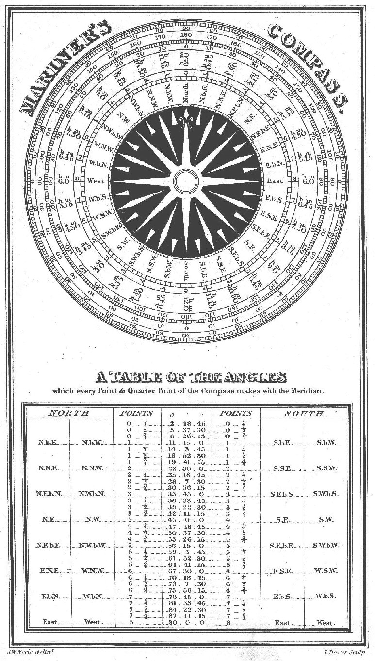
Compass rose
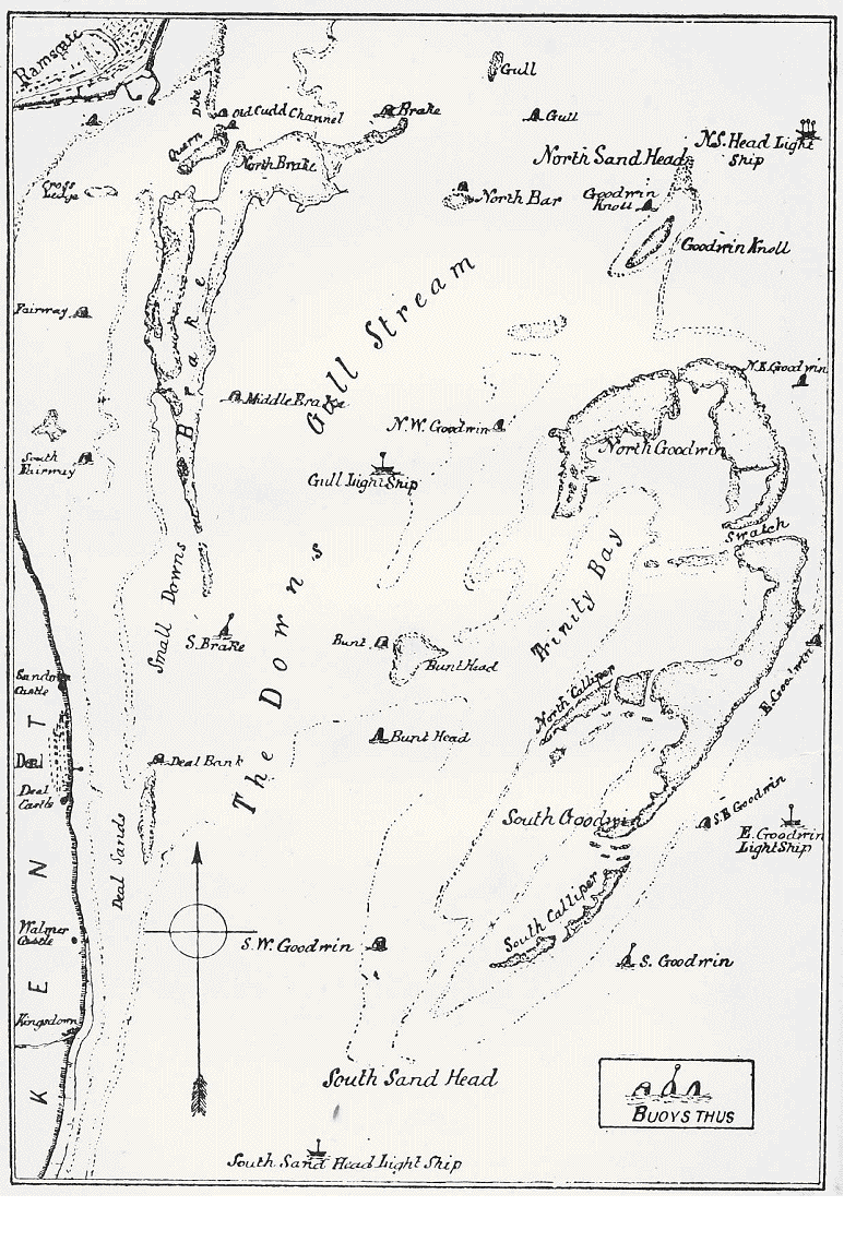
Chart of the Goodwin Sands in 1890
The Cry From The Sea and the Answer From the Shore | The Cry From The Sea and the Answer From the Shore 2 | The Cry From The Sea and the Answer From the Shore 3 | The Cry From The Sea and the Answer From the Shore 4 | The Cry From The Sea and the Answer From the Shore 5 | Margate Lifeboat | Ramsgate Lifeboat