Pictures of E Hodgkins holiday in Ramsgate 1928 | thanetonline blog More pictures Even more pictures
Title 91
EMR 2009.doc/Jan-09 11-1
11 Risk Assessment
Risk assessment incorporates the risk estimation and risk evaluation stages. The
likelihood of the potential hazards following possible pathways and presenting a
threat to the surrounding targets are assessed and considered with any site specific
factors which may affect the nature of the risks present. The ability to provide a
quantitative estimate of probability depends on the quantity and quality of data
available and the ability to input this into an established, scientifically based
procedure. This process is therefore an iterative one, a design tool to refine
engineering judgement and to provide guidance on those areas where further work
may be necessary to achieve a safe result.
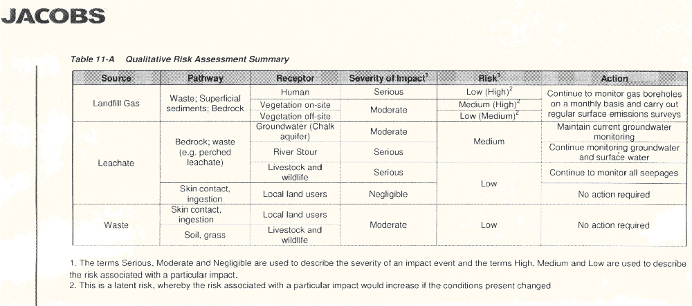
In the absence of appropriate guidance or data for a quantitative risk assessment,
Jacobs has formulated a qualitative risk assessment methodology. Firstly the
severity of the impact is identified and defined as serious, moderate or negligible.
Next the probable risk that the impact will occur is assessed and described using the
terms high, medium or low. The qualitative risk assessment for this site is shown in
Table 11-A.
11.1 State of Decomposition of Waste
The results of the gas monitoring indicate that certain areas of the site are still
actively gassing. The areas subject to more recent infilling are to the middle of the
site and are monitored by RB.6 and RB.L4. Typically, they show results for a site
within the methanogenesis state of decomposition with values of methane and
carbon dioxide reaching 65% and 35% respectively.
As the waste was deposited directly on to the marshes, water has been entering
parts of the waste. These areas of the waste will have been saturated, which will
increase the rate of decomposition of the waste and produce leachate.
Parts of the site were operational until the late 1980s and hence the degradation
process of the waste is estimated to continue for several years, possibly beyond a
further 20-30 years.
11.2 Landfill Gas
11.2.1 On-site
The Environment Agency have issued guidance[26] for monitoring landfill gas surface
emissions, the purpose being to demonstrate compliance with relevant
environmental legislation and in particular to quantify the total emissions of this
important greenhouse from the site as a whole.
The most recent surface emissions survey was carried out using a flame ionisation
detector (FID) to measure concentrations of methane close to the surface and site
features. Results indicated several areas where elevated emissions were recorded,
the highest of these was on the western boundary where a value of 42,123ppm was
detected. A limited number of other areas recorded emissions of over 1000ppm,
EMR 2009.doc/Jan-09 11-2
most of which were situated in the northern area of the site. Other areas were only
slightly elevated but all coincided with areas of poorer grass growth indicating the
risk to on-site vegetation.
Stunted tree growth towards the northern boundary was also noted during this and
previous walkover surveys with a strong odour of landfill gas noted in previous
years. The stunted tree growth may be due to poor management of the area, but
landfill gas cannot be ruled out.
Landfill gas venting out through small drilled holes in the side of the hollow metal
gate posts on the site was highlighted as a significant hazard in the 1999
Environmental Monitoring Report. It was recommended that all the hollow metal
gate posts on the site should be grouted up and the use of such gate posts is
prevented in future on landfill sites. The most recent walkover survey noted the
holes to remain with hazard warning labels placed on each gate post. The FID was
placed adjacent to these holes and recorded significantly elevated gas emissions.
Livestock and public users of the site are not considered to be at risk from landfill
gas.
The farm buildings in the south eastern corner of the site are currently disused. If
these buildings are to be used in the future, an additional risk assessment should be
performed.
11.2.2 Off-site
The underlying geology comprising of alluvial sands and gravels implies a great
potential for gas to migrate outside the boundaries of the site. However, the
presence of a high groundwater table and the site being bounded by the River Stour
and a ditch effectively eliminates the potential for gas to migrate any significant
distance on three sides. The potential for gas migration to the north is reduced due
to the marshy nature of the ground and the near surface groundwater.
The monitoring of the landfill gas in the majority of boreholes around the perimeter
of the site has not detected any significant levels of methane and confirms that gas
migration is unlikely to occur in this manner. Results from RB.BH2 in the southeastern
corner however showed an increase in methane concentrations during
recent monitoring with a maximum peak of 49.7% in June 2007. Borehole RB.3, also
along the eastern boundary, recorded elevated methane concentrations between
January 2000 and August 2005. These are now typically less than 1% with oxygen
levels recovering.
Gases can be dissolved in the groundwater and thereby migrate with the
groundwater flow. If at some location the pressure is reduced and the solubility limit
of the gas in water exceeded, the gas may bubble out of solution and form a
separate gaseous phase. If such degassing is allowed to occur in confined spaces
such as beneath building development, hazardous or explosive atmospheres may
develop.
EMR 2009.doc/Jan-09 11-3
Landfill gas migration has potential to have a serious severity of impact. Resultant
hazards include the depletion of oxygen in poorly ventilated areas, asphyxiation,
explosions, physiological harm, corrosion and toxic and ecotoxic effects.
At this site all potential receptors susceptible to significant harm from gas are on the
east side of the River Stour. There is very little potential for groundwater containing
dissolved gases from the landfill to flow beneath or into the river and beyond the
east bank without being greatly diluted. There is also no mechanism that would
produce a preferential passage of such gaseous groundwater. The risk of a hazard
occurring as a consequence of dissolved gases is considered very low.
11.3 Leachate
The high water table and permeable geology at Richborough creates conditions
whereby contamination of groundwater and local surface water courses is probably
inevitable. The main hazard to the surrounding environment is from high
concentrations of organics, as measured by determinands BOD, COD, NH4-N and
TOC. Discharge into freshwater systems of organic material can result in drastic
reductions in oxygen levels in the water body. As oxygen levels drop, anaerobic
bacteria, which can oxidise organic compounds without the presence of oxygen,
start to thrive. The end products from the activities of these bacteria are hydrogen
sulphide, methane and ammonia, all of which are toxic to most higher organisms.
Recent monitoring of the surface of the River Stour has not detected any evidence
of significant contamination from the landfill site. A comparison between monitoring
points S1, S3 and site A located near the disused Richborough Power Station by
EMU Environmental Ltd[21] in June 2000 showed slightly different results during the
same period. However, the results have been similar during the remaining
monitoring period. The peak in conductivity and chloride may be due to saline
intrusion.
Monitoring of the boreholes along the boundary shows possible influence from the
salinity of the River Stour and the leachate within the site, confirming the hydraulic
continuity between the landfill site, the groundwater and the River Stour. It is difficult
to establish the effects and distribution of pollution of such sites due to the
characteristics that such tidal sections of rivers exhibit, namely tidal movements,
salinity, fluctuations in temperature and oxygen, reduced species diversity and
sedimentation.
Although there is strong potential for contamination of the groundwater to occur from
the leachate percolating through the waste, there is some evidence that the
concentration of the contamination is not significant. For example NH4-N levels in
leachate ranged between 130mg/l to 1500mg/l and groundwater levels were less
than 35mg/l. This would suggest some of the determinands in the leachate have
been attenuated by the alluvial deposits or diluted by the groundwater. However,
sulphate levels were higher in the groundwater and the concentrations of some
metals were similar between the groundwater and leachate.
Any seepage of leachate into the river will be restricted by the permeability of the
alluvial deposit. Typical values of permeability of fine sands can be expected to be
10-6m/s and with a low driving head of approximately 1m the flow of leachate is not
EMR 2009.doc/Jan-09 11-4
expected to be significant. With the volume of water and natural flow of the river
plus the regular tidal movements that occur, any seepage of contaminants is
expected to be significantly diluted.
There is however a possibility that leachate could seep out at greater rates through
other pathways such as animal burrows. The therma-graphic survey carried out in
March 1999 would have detected such seepages as there should be a significant
temperature difference between the leachate and the river. As none were recorded
it is considered that leachate seepages by this means were not occurring.
The most extreme concentrations of the determinands has been found in the
western boundary ditch which is most probably due to the stagnant nature of the
ditch inhibiting any dilution or dispersion of contaminants.
The results from S7 in the pond were previously highlighted as not being particularly
conducive for wildlife however notes from the recent walkover survey indicate
vegetation to be well established with no visible sign of contamination.
Concentrations of certain determinands such as ammoniacal nitrogen and iron still
indicate the pond to be influenced by the landfill; however, the resultant impact upon
wildlife is uncertain.
The two options presented previously may still be considered if conditions are found
to deteriorate. These were:
- To line the lagoon with an impermeable membrane to prevent leachate
migration and surface water run-off into the lagoon. The lagoon can
then be populated with any desirable aquatic life.
- Alternatively, plant life can be introduced in an attempt to maintain
natural sustainable conditions in the lagoon. The low oxygen content
can be compensated for by planting oxygenating plant. This will then
allow macro invertebrates, which help to break down the organic matter,
to survive.
The water seepages previously encountered were clearly leachate seeping through
the capping material from a perched water table in the waste. The liquid emerging
from the site had high levels of phytotoxic components and thus will pose a potential
threat to the grass and consequently to the cattle permitted to graze the area.
However, since the last report many of these areas have been found to be dry for
long periods of the year. It is recommended that cattle and sheep are kept away
from any of these seepages which may once again occur during the wetter months.
11.4 Waste and Topsoil
A topsoil assessment was carried out in June 2006 and reported in July 2006[13] to
assess the current quality of the topsoil at the site in terms of establishing vegetation
and the agricultural benefit that may be gained from spreading green waste
compost over it. Any near surface contamination as a result of the use of the site
as landfill was also assessed in relation to its potential to cause harm to the
vegetation.
Chemical testing of the soil currently on-site revealed a lack in essential nutrients
needed for good plant growth, while testing of the green waste compost indicated it
EMR 2009.doc/Jan-09 11-5
to be rich in these nutrients and complying with BSI PAS 100 regulations governing
the quality of composts.
Consequently it was deemed that application of a 40mm thick layer of the compost
within the top 150mm of the soil would provide an agricultural benefit to the area.
11.5 Future Use and Life of Site
Gas production within parts of the site is showing methanogenic characteristics,
which is the stage in waste decomposition of longest duration. There is no accurate
method to determine the time period before the waste will stabilise due to the many
variables that affect it and the many guises in which these variables can exist.
However it is considered that full stable conditions will not be observed for at least
two decades.
To determine the point of stabilisation in WMP26A[8] it is stated that:
The authority (EA) must be satisfied that the condition of the land is unlikely to
cause pollution of the environment or harm to human health.
The risk of gas or leachate reaching a possible receptor depends on site-specific
factors and consultation documents issued by the EA for the guidance on landfill
completion[26] suggest that:
Completion criteria for a landfill will therefore be site specific and will be dependent
upon the sensitivity of the environment.
The guidance suggests that risk assessments using the tiered approach, the sourcepathway-
receptor methodology and the use of environmental benchmarks are
required with respect to the surrender and completion of a landfill.
Landfill sites present particular problems for development and after-use because of
the inherent hazards associated with them. Currently, the site is leased for cattle
grazing and there is a public footpath on the southern and eastern boundaries. This
is an ideal use as there will be little or no disturbance to the landfill capping material
and cattle prevent the growth of larger vegetation which could penetrate the capping
material.